የሼልፊሽ አካባቢ እገዳ ማስታወቂያ እና መግለጫ
ቁጥር 080-169፣ MATCHOTANK CREEK
ከሜይ 15 ፣ 2025ጀምሮ ተፈጻሚ
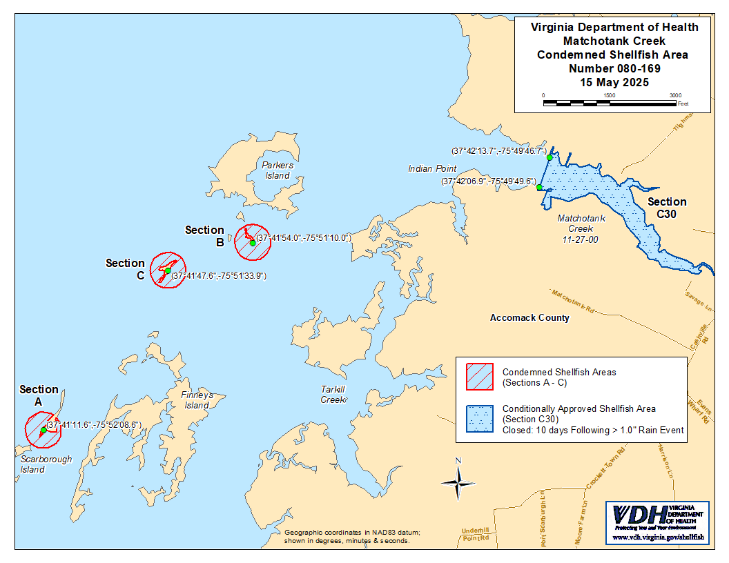
በአርዕስት 28.2 መሠረት፣ ምዕራፍ 8፣ §§ 28.2-803 እስከ 28.2-808፣ § 32.1-20፣ እና § 2.2-4002፣ Virginia ሕግ ክፍል B.16 ።
1. “የሼልፊሽ አካባቢ እገዳ ማስታወቂያ እና መግለጫ ቁጥር 080-169፣ Matchotank Creek”፣ ከማርች 15 2022 ጀምሮ ተግባራዊ የነበረው፣ ከሜይ 15 2025 ጀምሮ ተሰርዟል።
2. የተከለከለ የሼልፊሽ (የባህር ምግብ) አካባቢ ቁጥር 080-169 በክፍል A እስከ C እንደሚታየው፣ ከ 15 ሜይ 2022 ጀምሮ ተቋቁሟል። በVirginia ኮድ § 28.2-810 ላይ እንደተገለጸው በMarine Resources Commission ከተሰጠ ፈቃድ ውጪ፣ ለማንኛውም ዓላማ ከእነዚህ አካባቢዎች ሼልፊሽ መውሰድ ለማንኛውም ሰው፣ ድርጅት ወይም ኮርፖሬሽን ሕገ-ወጥ ነው። የእነዚህ አካባቢዎች ወሰኖች “Matchotank Creek, Condemned Shellfish Area Number 080-169, 15 May 2022” በሚል ርዕስ በተዘጋጀው እና የዚህ ማስታወቂያ አካል በሆነው ካርታ ላይ ይታያሉ።
3. እንደ ክፍል C30 የሚታየው የተከለከለ የሼልፊሽ አካባቢ ቁጥር 080-169፣ ከሜይ 15 ቀን 2025 ጀምሮ ተግባራዊ እንዲሆን ተወስኗል። በቨርጂኒያ ኮድ § 28.2-808(3) መሠረት፣ እንዲህ ዓይነቱ ሁኔታዊ እገዳ የተመሠረተው ከልክ ያለፈ ዝናብ በሚያስከትለው ሊገመት በሚችል የብክለት ክስተት ላይ ነው። ይህ አካባቢ በOnancock Creek ውስጥ ከጠቅላላው 1 ኢንች በላይ በሆነ የ 24ሰዓት የዝናብ ክስተት በሚቀጥለው ቀን በ 12:01 ጥዋት ወደ ዝግ ሁኔታ ይቀየራል። ጠቅላላ የ 24ሰዓት ዝናብን የሚያመለክተው የመረጃ ምንጭ የብሔራዊ ውቅያኖስ እና የከባቢ አየር አስተዳደር (National Oceanic and Atmospheric Administration) ባለብዙ ዳሳሽ የዝናብ ግምት (Multisensor Precipitation Estimator) ለኬክሮስ / ኬንትሮስ መጋጠሚያ (37.72015099,-75.78875139 ይሆናል። አስርዮሽ ዲግሪዎች)፣ ወይም (37°43'12.5",-75°47'19.5" ዲግሪዎች፣ ደቂቃዎች እና ሰከንዶች)። የ 24ሰዓት የዝናብ ክስተትን ለመለካት የሚያገለግለው የጊዜ ክፍተት፣ ዝግ ሁኔታው ተፈጻሚ ከመሆኑ ቀን በፊት ባለው ቀን በ 8:00 ከሰዓት በኋላ የሚያበቃው የ 24ሰዓት ጊዜ ይሆናል። በሁኔታዎች የጸደቀው አካባቢ የተዘጋበት ሁኔታ ለ 10 የቀን መቁጠሪያ ቀናት በሥራ ላይ ይቆያል፤ እንዲሁም ከተዘጋበት ውጤታማ ቀን ጀምሮ በ 11ኛው የቀን መቁጠሪያ ቀን በ 12:01 ጥዋት ወደ ክፍት ሁኔታ ይመለሳል። በMarine Resources Commission ከተሰጠ ፈቃድ ውጪ፣ በVirginia ሕግ ክፍል 28.2-810 እንደተደነገገው፣ ይህ አካባቢ በተዘጋበት ወቅት ማንኛውም ሰው፣ ድርጅት ወይም ኮርፖሬሽን ለየትኛውም ዓላማ ሼልፊሽ መውሰድ ሕገ-ወጥ ነው። የዚህ አካባቢ ወሰኖች “Matchotank Creek, Condemned Shellfish Area Number 080-169, 15 May 2025” በሚል ርዕስ በተዘጋጀው እና የዚህ ማስታወቂያ አካል በሆነው ካርታ ላይ ይታያሉ።
4. የጤና መምሪያው በማንኛውም ጊዜ በማንኛውም ፍላጎት ያለው አካል የሚቀርቡ አቤቱታዎችን ይህንን ትዕዛዝ እንደገና እንዲታይ ወይም እንዲሻሻል በተመለከተ ይቀበላል፣ ይመለከታል እንዲሁም ምላሽ ይሰጣል።
የተወረሰ ቦታ ቁጥር 080-169ወሰኖች
ሀ. የተከለከለው አካባቢ በChesapeake Bay አቅራቢያ በScarborough Island የሚገኘውን ክፍል ያካትታል፤ ይህም በኬክሮስ/ኬንትሮስ ካርታ መጋጠሚያ (37°41'11.6",-75°52'08.6") ላይ በሚገኝ ነጥብ ዙሪያ በ 120 ሜትር ራዲየስ ክበብ የታጠረ ነው።
ለ. የተከለከለው አካባቢ በፓርከርስ ደሴት (Parkers Island) አቅራቢያ የሚገኘውን የChesapeake ቤይ ክፍል ያካትታል፤ ይህም በኬክሮስ/ኬንትሮስ ካርታ መጋጠሚያ (37°41'54.0",-75°51'10.0") ላይ በሚገኝ ነጥብ ዙሪያ በ 120 ሜትር ራዲየስ ክብ የታጠረ ነው።
ሐ. የተከለከለው አካባቢ በFinneys Island በስተሰሜን የሚገኘውን የChesapeake Bay ክፍል ያካትታል፤ ይህም በኬክሮስ / ኬንትሮስ ካርታ መጋጠሚያ (37°41'47.6",-75°51'33.9") ላይ በሚገኝ ነጥብ ዙሪያ በ 120 ሜትር ራዲየስ ክብ የታጠረ ነው።
C30. በሁኔታዎች የጸደቀው አካባቢ ሁሉንም የMatchotank Creek እና ገባር ወንዞቹን፣ በኬክሮስ / ኬንትሮስ ካርታ መጋጠሚያ (37°42'13.7",-75°49'46.7") እና በመጋጠሚያ (37°42'06.9",-75°49'49.6") መካከል በተሳለ መስመር ላይ የሚገኙትን ያካትታል።