የሼልፊሽ አካባቢ ክልከላ ማስታወቂያ እና መግለጫ
ቁጥር 077-138፣ HUNTING፣ BAGWELL እና DEEP CREEKS
ከ 15 ጁን 2026ጀምሮ ተግባራዊ ይሆናል
በአርዕስት 28.2 መሠረት፣ ምዕራፍ 8፣ § 28.2-803 እስከ 28.2-808፣ § 32.1-20፣ እና § 2.2-4002፣ B.16 of the Code of Virginia:
1. “የሼልፊሽ አካባቢ እገዳ ማስታወቂያ እና መግለጫ ቁጥር 077-138፣ Hunting፣ Bagwell እና Deep Creeks”፣ ከኦገስት 15 ቀን 2025 ጀምሮ ተግባራዊ የነበረው፣ ከጁን 15 ቀን 2026 ጀምሮ ተሰርዟል።
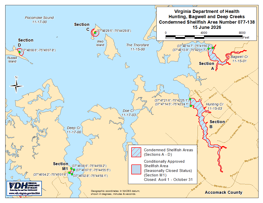
2. እንደ ክፍሎች A እስከ D የሚታየው የተከለከለ የሼልፊሽ አካባቢ ቁጥር 077-138፣ ከ 15 ጁን 2026 ጀምሮ ተግባራዊ እንዲሆን ተቋቁሟል። በVirginia ኮድ § 28.2-810 እንደተደነገገው፣ በMarine Resources Commission ከተሰጠ ፈቃድ ውጪ፣ ማንኛውም ሰው፣ ድርጅት ወይም ኮርፖሬሽን ከእነዚህ አካባቢዎች ለየትኛውም ዓላማ ሼልፊሽ መውሰድ ሕገ-ወጥ ነው። የእነዚህ አካባቢዎች ወሰኖች “Hunting, Bagwell and Deep Creeks, Condemned Shellfish Area Number 077-138, 15 June 2026” በሚል ርዕስ በተዘጋጀው ካርታ ላይ ይታያሉ፣ ይህም የዚህ ማስታወቂያ አካል ነው።
3. እንደ ክፍል M1 የሚታየው በሁኔታዎች የጸደቀ የሼልፊሽ አካባቢ (በወቅቱ የተዘጋ ሁኔታ) ቁጥር 077-138፣ ከ 15 ጁን 2026 ጀምሮ ተግባራዊ እንዲሆን ተቋቁሟል፣ ከዚያም በኋላ እስከሚሰረዝ ድረስ በየዓመቱ ከኤፕሪል የመጀመሪያ ቀን እስከ ኦክቶበር የመጨረሻ ቀን ድረስ ተግባራዊ ሆኖ ይቆያል። ማንኛውም ሰው፣ ድርጅት ወይም ኮርፖሬሽን በዚህ አካባቢ የተዘጋበት ሁኔታ ባለበት ወቅት ለማንኛውም ዓላማ ሼልፊሽ (shellfish) መውሰድ ሕገ-ወጥ ነው፤ ሆኖም በቨርጂኒያ ሕግ (Code of Virginia) አንቀጽ § 28.2-810 እንደተደነገገው በMarine Resources Commission በተሰጠ ፈቃድ ሲፈቀድ ብቻ የተለየ ነው። የዚህ አካባቢ ወሰኖች የዚህ ማስታወቂያ አካል በሆነው “Hunting, Bagwell and Deep Creeks, Condemned Shellfish Number 077-138, 15 June 2026” በተሰኘው ካርታ ላይ ይታያሉ።
4. የጤና መምሪያው በማንኛውም ጊዜ በማንኛውም ፍላጎት ያለው አካል የሚቀርቡ አቤቱታዎችን ይህንን ትዕዛዝ እንደገና እንዲታይ ወይም እንዲሻሻል በተመለከተ ይቀበላል፣ ይመለከታል እንዲሁም ምላሽ ይሰጣል።
የተወረሰ ቦታ ቁጥር 077-138ወሰኖች
ሀ. የተከለከለው አካባቢ የባግዌል ክሪክ (Bagwell Creek) እና ገባር ወንዞቹን ያካተተ ሲሆን፣ ይህም በኬክሮስ/ኬንትሮስ ካርታ መጋጠሚያ (37°48'13.9",-75°42'01.7") እና (37°48'14.7",-75°41'56.2") መካከል በተሳለ መስመር ላይ የሚገኘውን ክፍል ያጠቃልላል።
ለ. የተከለከለው አካባቢ የHunting Creekን እና ገባር ወንዞቹን ያካተተ ሲሆን፣ ይህም በኬክሮስ / ኬንትሮስ ካርታ መጋጠሚያ (37°47'21.6",-75°42'25.1") እና በካርታ መጋጠሚያ (37°47'14.5",-75°42'24.1") መካከል በተሳለ መስመር ላይ የሚገኘውን ክፍል ያጠቃልላል።
ሐ. የተከለከለው ቦታ በዌብ ደሴት (Web Island) የሚገኘውን የፖኮሞክ ሳውንድ (Pocomoke Sound) ክፍል ያካትታል፤ ይህም በኬክሮስ/ኬንትሮስ ካርታ መጋጠሚያ (37°48'29.5",-75°44'29.8") ዙሪያ ባለው 125 ሜትር ራዲየስ ውስጥ ይገኛል።
መ. የተከለከለው አካባቢ በRussell ደሴት የሚገኘውን የPocomoke Sound ክፍል፣ በኬክሮስ/ኬንትሮስ ካርታ መጋጠሚያ (37°48'08.6",-75°46'07.8") ዙሪያ ባለው የ 125 ሜትር ራዲየስ ውስጥ ያካትታል።
M1. በሁኔታዊ ሁኔታ የጸደቀው (በወቅታዊ ሁኔታ የተዘጋ) አካባቢ፣ በኬክሮስ / ኬንትሮስ ካርታ መጋጠሚያ (37°46'08.6",-75°44'59.2") እና በካርታ መጋጠሚያ (37°46'07.5",-75°44'55.5") መካከል በተሳለ መስመር ውስጥ የሚገኘውን የDeep Creek ክፍል ያካትታል፣ የካርታ መጋጠሚያ (37°46'02.8",-75°44'58.1")፣ እና የካርታ መጋጠሚያ (37°46'04.2",-75°45'01.6")።