የሼልፊሽ አካባቢ እገዳ ማስታወቂያ እና መግለጫ
ቁጥር 078-086፣ ታንጂየር ደሴት
ከ 15 ማርች 2025ጀምሮ ተግባራዊ ይሆናል
በአርዕስት 28.2 መሠረት፣ ምዕራፍ 8፣ §§28.2-803 በ 28.2-808፣ §32.1-20፣ እና §2.2-4002 በኩል፣ B.16 of the Code of Virginia:
1. “የሼልፊሽ አካባቢ ኮንደምኔሽን ቁጥር 078-086፣ ታንጀር ደሴት ማስታወቂያ እና መግለጫ”፣ ከኖቬምበር 6 ቀን 2013 ጀምሮ ተግባራዊ የነበረው፣ ከማርች 15 ቀን 2025 ጀምሮ ተሰርዟል።
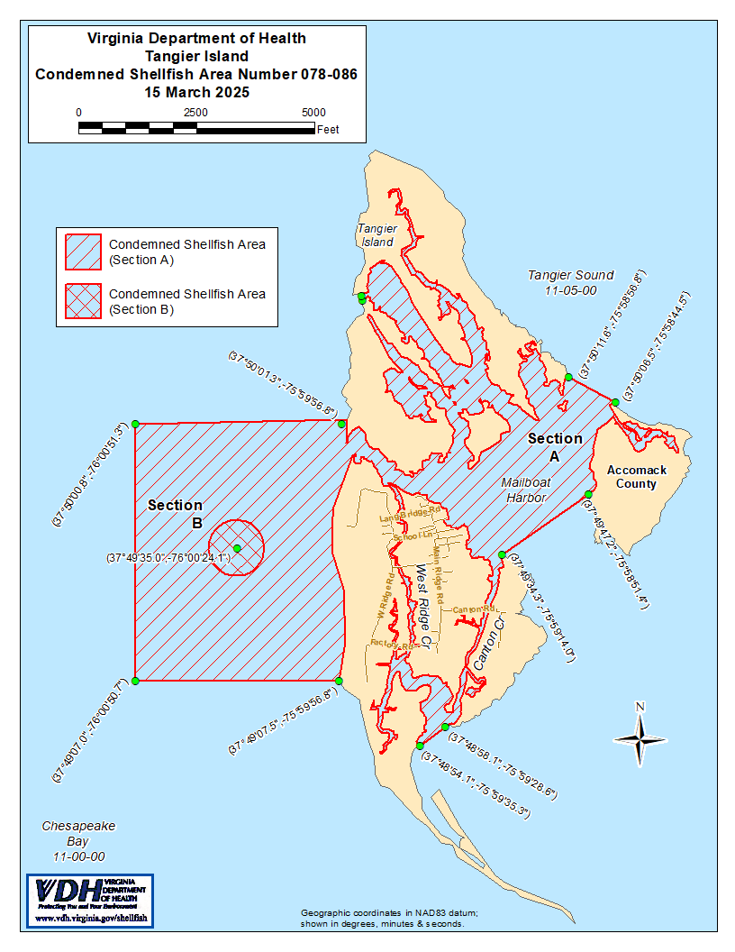
2. የተከለከለ የሼልፊሽ አካባቢ ቁጥር 078-086፣ እንደ ክፍል A እና B የሚታየው፣ ከ 15 መጋቢት 2025 ጀምሮ ተግባራዊ እንዲሆን ተወስኗል። ክፍል Aን በተመለከተ፣ በMarine Resources Commission ከተሰጠ ፈቃድ ውጪ፣ በVirginia ኮድ ክፍል 28.2-810 እንደተደነገገው፣ ለማንኛውም ዓላማ ከዚህ አካባቢ ሼልፊሽ (የባህር ውስጥ ዛጎል ያላቸው እንስሳት) መውሰድ ለማንኛውም ሰው፣ ድርጅት ወይም ኮርፖሬሽን ሕገ-ወጥ ነው። ክፍል Bን በተመለከተ፣ ለማንኛውም ዓላማ ከዚህ አካባቢ ሼልፊሽ (የባህር ውስጥ እንስሳትን) መውሰድ ለማንኛውም ሰው፣ ድርጅት ወይም ኮርፖሬሽን ሕገ-ወጥ ነው። የእነዚህ አካባቢዎች ወሰኖች “Tangier Island, Condemned Shellfish Area Number 078-086, 15 March 2025” በሚል ርዕስ በተዘጋጀው ካርታ ላይ ይታያሉ፣ ይህም የዚህ ማስታወቂያ አካል ነው።
3. በሁኔታዎች የጸደቀው የሼልፊሽ (የባህር ምግብ) አካባቢ (የተዘጋ ሁኔታ) ቁጥር 078-086፣ እንደ ክፍል M1 የሚታየው፣ በዚህ ማስታወቂያ ከ 15 ማርች 2025 ጀምሮ ተግባራዊ ይሆናል። በቨርጂኒያ ሕግ (Code of Virginia) § 28.2-810 ላይ እንደተደነገገው፣ በMarine Resources Commission ከተሰጠ ፈቃድ ውጪ፣ በማንኛውም ዓላማ በዚህ ወቅት ከዚህ አካባቢ ሼልፊሽ መውሰድ ለማንኛውም ሰው፣ ድርጅት ወይም ኮርፖሬሽን ሕገ-ወጥ ይሆናል። የዚህ አካባቢ ወሰኖች “ታንጂየር ደሴት፣ የተወገዘ የሼልፊሽ (የባህር ምግብ) አካባቢ ቁጥር 078-086፣ 15 ማርች 2025” በሚል ርዕስ በተዘጋጀው ካርታ ላይ ይታያሉ፤ ይህም የዚህ ማስታወቂያ አካል ነው።
4. የጤና መምሪያው በማንኛውም ጊዜ በማንኛውም ፍላጎት ያለው አካል የሚቀርቡ አቤቱታዎችን ይህንን ትዕዛዝ እንደገና እንዲታይ ወይም እንዲሻሻል በተመለከተ ይቀበላል፣ ይመለከታል እንዲሁም ምላሽ ይሰጣል።
የተወረሰ ቦታ ቁጥር 078-086ወሰኖች
ሀ. የተከለከለው አካባቢ አብዛኛውን የMailboat Harbor፣ የTangier North Channel ውኃዎችን እና በክፍል B የተገለጸውን አካባቢ የሚከቡትን የChesapeake Bay ውኃዎችን ያካትታል። እነዚህ ውኃዎች ከኬክሮስ / ኬንትሮስ ካርታ መጋጠሚያ (37°50'11.6",-75°58'56.8") እና ከካርታ መጋጠሚያ (37°50'06.5",-75°58'44.5") በተሳለ መስመር ውስጥ ይገኛሉ፤ እንዲሁም ከካርታ መጋጠሚያ (37°49'47.2",-75°58'51.4") እና ከካርታ መጋጠሚያ (37°49'34.3",-75°59'14.0") በተሳለ ሁለተኛ መስመር ውስጥ፣ እንዲሁም ከካርታ መጋጠሚያ (37°48'58.1",-75°59'28.6") ወደ ካርታ መጋጠሚያ (37°48'54.1",-75°59'35.3") በተሳለ ሦስተኛ መስመር ውስጥ፣ እንዲሁም ከካርታ መጋጠሚያ (37°49'07.5",-75°59'56.8") በተሳለ አራተኛ መስመር ውስጥ ይገኛሉ፣ የካርታ መጋጠሚያ (37°49'07.0",-76°00'50.7")፣ የካርታ መጋጠሚያ (37°50'00.8",-76°00'51.3")፣ እና የካርታ መጋጠሚያ (37°50'01.3",-75°59'56.8" እባክዎ መጋጠሚያውን ይተኩ)፤ እንዲሁም ከካርታ መጋጠሚያ እና ከካርታ መጋጠሚያ በተሳለ አምስተኛ መስመር ውስጥ፤ ነገር ግን በክፍል B የተገለጸውን አካባቢ ሳይጨምር።
ለ. የተከለከለው አካባቢ በ 200 ያርድ ራዲየስ ክብ የተከበበውን Chesapeake Bay ክፍል በሙሉ ያካትታል፤ ይህም በኬክሮስ/ኬንትሮስ ካርታ መጋጠሚያ (37°49'35.0",-76°00'24.1") የተገለጸ ነጥብ ነው።
M1. በሁኔታዎች የጸደቀው አካባቢ (የተዘጋ ሁኔታ) የሜይልቦት ሃርበር (Mailboat Harbor) እና የታንጂየር ሰሜን ቻናል (Tangier North Channel) ክፍልን ያካትታል፤ ይህም ከኬክሮስ / ኬንትሮስ ካርታ መጋጠሚያ (37°49'57.3",-75°59'55.6") እና ከመጋጠሚያ (37°49'55.1" በስተምስራቅ የሚገኝ፣
-75°59'52.9"); እንዲሁም ከካርታ መጋጠሚያ (37°50'02.7",-75°59'04.6") እና ከካርታ መጋጠሚያ (37°49'34.3",-75°59'14.0") በተሳለ መስመር በስተ ምዕራብ፤ እንዲሁም ከካርታ መጋጠሚያ (37°50'04.7",-75°59'29.4") እና ከካርታ መጋጠሚያ (37°50'08.9",-75°59'14.7") በተሳለ መስመር በስተ ደቡብ፤ እንዲሁም ከዌስት ሪጅ ክሪክ (West Ridge Creek) ማዶ ከካርታ መጋጠሚያ (37°49'11.1",-75°59'43.3") እና ከካርታ መጋጠሚያ (37°49'12.0",-75°59'39.63749011755928037485817559286") በተሳለ መስመር በስተ ሰሜን፤ እና ከካንቶን ክሪክ (Canton Creek) ማዶ ከተሳለ ሁለተኛ መስመር በስተ ሰሜን፤ እና በክፍል A በተገለጸው አካባቢ ውስጥ የተካተተ።