የሼልፊሽ አካባቢ እገዳ ማስታወቂያ እና መግለጫ
ቁጥር 080-013፣ ኦናንኮክ ክሪክ (ONANCOCK CREEK)
ከ 15 ኤፕሪል 2026ጀምሮ በሥራ ላይ የሚውል
በአርዕስት 28.2 መሠረት፣ ምዕራፍ 8፣ §§ 28.2-803 እስከ 28.2-808፣ § 32.1-20፣ እና § 2.2-4002፣ B.16 of the Code of Virginia:
1. “የሼልፊሽ አካባቢ ክልከላ ማስታወቂያ እና መግለጫ ቁጥር 080-013፣ ኦናንኮክ ክሪክ (Onancock Creek)፣” ከሜይ 17 ቀን 2025 ዓ.ም ጀምሮ ተግባራዊ የነበረው፣ ከኤፕሪል 15 ቀን 2026 ዓ.ም ጀምሮ ተሰርዟል።
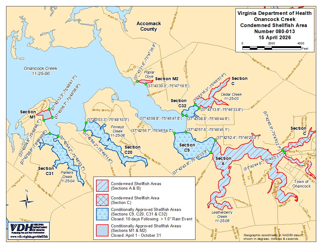
2. እንደ ክፍል A፣ B እና C የሚታየው የተከለከለ የሼልፊሽ አካባቢ ቁጥር 080-013 ከ 15 ኤፕሪል 2026 ጀምሮ ተግባራዊ እንዲሆን ተቋቁሟል። ክፍል A እና Bን በተመለከተ፣ በVirginia ኮድ § 28.2-810 እንደተደነገገው፣ በMarine Resources Commission ከተሰጠ ፈቃድ ውጪ፣ ለማንኛውም ዓላማ ከእነዚህ አካባቢዎች ሼልፊሽ መውሰድ ለማንኛውም ሰው፣ ድርጅት ወይም ኮርፖሬሽን ሕገ-ወጥ ነው። ክፍል Cን በተመለከተ፣ ማንኛውም ሰው፣ ድርጅት ወይም ኮርፖሬሽን ከዚህ አካባቢ ለየትኛውም ዓላማ ሼልፊሽ (የባህር ውስጥ ዛጎል ያላቸው እንስሳት) መውሰድ ሕገወጥ ነው። የእነዚህ አካባቢዎች ወሰኖች “Onancock Creek, Condemned Shellfish Area Number 080-013, 15 April 2026” በሚል ርዕስ በተዘጋጀው እና የዚህ ማስታወቂያ አካል በሆነው ካርታ ላይ ይታያሉ።
3. የተከለከለ የሼልፊሽ (የባህር ምግብ) አካባቢ ቁጥር 080-013፣ እንደ ክፍሎች C9፣ C20፣ C31 እና C32 የሚታየው፣ ከኤፕሪል 15 ቀን 2026 ጀምሮ ተግባራዊ እንዲሆን በዚህ ተወስኗል። በቨርጂኒያ ኮድ § 28.2-808(3) መሠረት፣ እንዲህ ዓይነቱ ሁኔታዊ እገዳ የተመሠረተው ከከፍተኛ ዝናብ በሚመጡ ሊገመቱ በሚችሉ የብክለት ክስተቶች ላይ ነው። እነዚህ አካባቢዎች በኦናንኮክ ክሪክ (Onancock Creek) ከ 1 ኢንች በላይ በሆነ የዝናብ መጠን በ 24ሰዓት የዝናብ ክስተት በነጋታው በ 12:01 ጥዋት በተዘጋ ሁኔታ ውስጥ ይቀመጣሉ። ጠቅላላ የ 24ሰዓት ዝናብን የሚያመለክተው የመረጃ ምንጭ የብሔራዊ ውቅያኖስ እና የከባቢ አየር አስተዳደር (National Oceanic and Atmospheric Administration) ባለብዙ ዳሳሽ የዝናብ ግምት (Multisensor Precipitation Estimator) ለኬክሮስ / ኬንትሮስ መጋጠሚያ (37.72015099,-75.78875139 ይሆናል። አስርዮሽ ዲግሪዎች)፣ ወይም (37°43'12.5",-75°47'19.5" ዲግሪዎች፣ ደቂቃዎች እና ሰከንዶች)። የ 24ሰዓት የዝናብ ክስተትን ለመለካት የሚያገለግለው የጊዜ ክፍተት ዝግ ሁኔታው ከመጀመሩ በፊት ባለው ቀን በ 8:00 ከሰዓት በኋላ የሚያበቃው የ 24ሰዓት ጊዜ ይሆናል። የሁኔታዊ የጸደቀው አካባቢ ዝግ ሁኔታ ለ 10 የቀን መቁጠሪያ ቀናት በሥራ ላይ ይቆያል እና ዝግ ሁኔታው ከጀመረበት ቀን ጀምሮ በ 11ኛው የቀን መቁጠሪያ ቀን በ 12:01 ጥዋት ወደ ክፍት ሁኔታ ይመለሳል። በቨርጂኒያ ኮድ ክፍል 28.2-810 እንደተደነገገው፣ በMarine Resources Commission ከተሰጠ ፈቃድ በስተቀር፣ ዝግ በሆነበት ጊዜ ማንኛውም ሰው፣ ድርጅት ወይም ኮርፖሬሽን ከእነዚህ አካባቢዎች ለየትኛውም ዓላማ ሼልፊሽ (የባህር ምግብ) መውሰድ ሕገ-ወጥ ነው። የእነዚህ አካባቢዎች ወሰኖች በዚህ ማስታወቂያ አካል በሆነው “ኦናንኮክ ክሪክ፣ የተከለከለ የሼልፊሽ አካባቢ ቁጥር 080-013፣ ኤፕሪል 15 ቀን 2026” በተሰኘው ካርታ ላይ ይታያሉ።
4. በሁኔታዎች የጸደቀ የሼልፊሽ አካባቢ (በወቅታዊ ሁኔታ የተዘጋ) ቁጥር 080-013፣ እንደ ክፍል M1 እና M2 የሚታየው፣ ከኤፕሪል 15 ቀን 2026 ጀምሮ ተቋቁሟል፣ እና ከዚያ በኋላ በየዓመቱ ከኤፕሪል የመጀመሪያ ቀን እስከ ኦክቶበር የመጨረሻ ቀን ድረስ እስኪሰረዝ ድረስ በሥራ ላይ ይቆያል። በተዘጋ ሁኔታ ውስጥ በሚቆይበት ጊዜ፣ በMarine Resources Commission ከተሰጠ ፈቃድ ውጪ፣ በVirginia ሕግ § 28.2-810 እንደተደነገገው፣ ማንኛውም ሰው፣ ድርጅት ወይም ኮርፖሬሽን በእነዚህ አካባቢዎች ውስጥ ለየትኛውም ዓላማ ሼልፊሽ መውሰድ ሕገ-ወጥ ነው። የእነዚህ አካባቢዎች ወሰኖች “Onancock Creek, Condemned Shellfish Area Number 080-013, 15 April 2026” በሚል ርዕስ በተዘጋጀው ካርታ ላይ ይታያሉ፣ ይህም የዚህ ማስታወቂያ አካል ነው።
5. በሁኔታዎች የጸደቀ የሼልፊሽ አካባቢ (የተዘጋ ሁኔታ) ቁጥር 080-013፣ እንደ ክፍሎች M3 እና M4 የሚታየው፣ ከኤፕሪል 15 ቀን 2026 ጀምሮ ተግባራዊ እንዲሆን ተቋቁሟል። ማንኛውም ሰው፣ ድርጅት ወይም ኮርፖሬሽን እነዚህ አካባቢዎች በተዘጉበት ጊዜ፣ በVirginia ሕግ አንቀጽ § 28.2-810 እንደተደነገገው በMarine Resources Commission ከተሰጠ ፈቃድ ውጪ፣ ለማንኛውም ዓላማ ከእነዚህ አካባቢዎች የባህር ምግቦችን (shellfish) መውሰድ ሕገ-ወጥ ነው። የእነዚህ አካባቢዎች ወሰኖች “Onancock Creek, Condemned Shellfish Area Number 080-013, 15 April 2026” በሚል ርዕስ በተዘጋጀው ካርታ ላይ ይታያሉ፣ ይህም የዚህ ማስታወቂያ አካል ነው።
6. የጤና መምሪያው በማንኛውም ጊዜ በማንኛውም ፍላጎት ያለው አካል የሚቀርቡ አቤቱታዎችን ይህንን ትዕዛዝ እንደገና እንዲታይ ወይም እንዲሻሻል በተመለከተ ይቀበላል፣ ይመለከታል እንዲሁም ምላሽ ይሰጣል።
የተወረሰ ቦታ ቁጥር 080-013ወሰኖች
ሀ. የተከለከለው አካባቢ በOnancock Creek እና ገባር ወንዞቹ ላይ፣ በኬክሮስ/ኬንትሮስ ካርታ መጋጠሚያ (37°42'43.8",-75°46'23.9") እና በካርታ መጋጠሚያ (37°42'52.4",-75°46'20.1") መካከል በተሳለ መስመር ላይ የሚገኘውን ክፍል ያካትታል፤ ነገር ግን እንደ ክፍል C የተገለጸውን አካባቢ አያካትትም።
ለ. የተከለከለው አካባቢ የሲዳር ክሪክን (Cedar Creek) እና ገባር ወንዞቹን፣ በኬክሮስ/ኬንትሮስ ካርታ መጋጠሚያ (37°43'16.3",-75°46'37.4") እና በመጋጠሚያ (37°43'13.9",-75°46'33.8") መካከል በተሳለ መስመር ላይ የሚገኙትን ክፍሎች ያካትታል።
ሐ. የተከለከለው አካባቢ የNorth Branch of Onancock Creekን በሙሉ፣ በኬክሮስ/ኬንትሮስ ካርታ መጋጠሚያ (37°42'45.9",-75°45'22.7") እና በካርታ መጋጠሚያ (37°42'44.6",-75°45'21.1") መካከል በተሳለ መስመር ላይ የሚገኘውን የላይኛው ክፍል ያካትታል።
C9. በሁኔታዎች የጸደቀው አካባቢ የኦናንኮክ ክሪክን (Onancock Creek) እና ገባር ወንዞቹን፣ በኬክሮስ/ኬንትሮስ ካርታ መጋጠሚያ (37°42'56.7",-75°46'54.7") እና በካርታ መጋጠሚያ (37°42'57.6",-75°46'45.1") መካከል በተሳለ መስመር ላይ የሚገኙትን ክፍሎች ያካትታል፤ ነገር ግን ክፍሎች A እና C ተብለው የተገለጹትን አካባቢዎች አያካትትም።
C20. በሁኔታዎች የጸደቀው አካባቢ የFinneys Creekን ክፍል እና ገባር ወንዞቹን፣ በኬክሮስ/ኬንትሮስ ካርታ መጋጠሚያ (37°42'58.2",-75°48'11.6") እና በመጋጠሚያ (37°43'03.3",-75°48'10.0") መካከል በተሳለ መስመር ላይ የሚገኙትን ያካትታል።
C31. በቅድመ ሁኔታ የጸደቀው አካባቢ የፓርከርስ ክሪክን (Parkers Creek) እና ገባሮቹን ክፍል ያካትታል፤ ይህም በኬክሮስ/ኬንትሮስ ካርታ መጋጠሚያ (37°42'55.8",-75°48'40.8") እና በመጋጠሚያ (37°42'54.2",-75°48'33.7") መካከል በተሳለ መስመር በኩል ወደ ላይኛው ክፍል የሚገኝ ነው።
C32. በሁኔታዎች የጸደቀው አካባቢ የሲዳር ክሪክን (Cedar Creek) እና ገባር ወንዞቹን፣ በኬክሮስ/ኬንትሮስ ካርታ መጋጠሚያ (37°43'08.8",-75°46'47.8") እና በመጋጠሚያ (37°43'08.8",-75°46'44.9") መካከል በተሳለ መስመር ላይ የሚገኙትን ክፍሎች ያካትታል፤ ነገር ግን ክፍል B ተብሎ የተገለጸውን አካባቢ አያካትትም።
M1. በሁኔታዎች የጸደቀው አካባቢ (በወቅታዊ ሁኔታ የተዘጋ) የፓርከር ክሪክ (Parker Creek) ክፍልን ያጠቃልላል፤ ይህም በኬክሮስ/ኬንትሮስ ካርታ መጋጠሚያ (37°43'12.3",-75°48'41.7")፣ ካርታ መጋጠሚያ (37°43'06.7",-75°48'38.9")፣ እና ካርታ መጋጠሚያ (37°43'04.8",-75°48'46.1") መካከል በተሳለ መስመር ወደ ውስጥኛው ክፍል የሚገኝ ነው።
M2. በሁኔታዎች የጸደቀው አካባቢ (በወቅታዊ ሁኔታ የተዘጋ) የPoplar Coveን ክፍል፣ በኬክሮስ / ኬንትሮስ ካርታ መጋጠሚያ (37°43'31.8",-75°47'26.9") እና በመጋጠሚያ (37°43'30.0",-75°47'19.5") መካከል በተሳለ መስመር የውስጥ እና የላይኛው ክፍልን ያካትታል።
M3. በሁኔታዊ ሁኔታ የጸደቀው አካባቢ (በወቅታዊ ሁኔታ የተዘጋ) የኦናንኮክ ክሪክ (Onancock Creek) ማዕከላዊ ቅርንጫፍ በኬክሮስ / ኬንትሮስ ካርታ መጋጠሚያ (37°42'43.9",-75°45'25.6") እና በመጋጠሚያ (37°42'41.2",-75°45'22.5") መካከል በተሳለ መስመር ላይ የሚገኘውን ክፍል፣ እንዲሁም በመጋጠሚያ (37°42'45.9",-75°45'22.7") እና በመጋጠሚያ (37°42'44.6",-75°45'21.1") መካከል በተሳለ ሁለተኛ መስመር በታችኛው ክፍል፣ እና በመጋጠሚያ (37°42'37.6",-75°45'15.3") እና በመጋጠሚያ (37°42'39.1",-75°45'13.1") መካከል በተሳለ ሦስተኛ መስመር በታችኛው ክፍል ያካትታል፤ ይህም የክፍል A አካል ሆኖ ይታያል።
M4. በሁኔታዎች የጸደቀው አካባቢ (በወቅታዊ ሁኔታ የተዘጋ) የSouth Branch of Onancock Creek ክፍልን ያካትታል፣ ይህም በኬክሮስ / ኬንትሮስ ካርታ መጋጠሚያ (37°42'35.2",-75°45'27.8")፣ ካርታ መጋጠሚያ (37°42'34.5",-75°45'31.0")፣ እና ካርታ መጋጠሚያ (37°42'29.9",-75°45'27.9") መካከል በተሳለ መስመር ላይ የሚገኝ ሲሆን፤ ይህም እንደ ክፍል A አካል ሆኖ ይታያል።