የሼልፊሽ አካባቢ እገዳ ማስታወቂያ እና መግለጫ
ቁጥር 100-097፣ SWANS GUT CREEK እና COCKLE POINT
ከ 15 ጃኑዋሪ 2026ጀምሮ ተግባራዊ ይሆናል
በአርዕስት 28.2 መሠረት፣ ምዕራፍ 8፣ §§ 28.2-803 እስከ 28.2-808፣ § 32.1-20፣ እና § 2.2-4002፣ Virginia ሕግ ክፍል B.16 ።
1. “የሼልፊሽ አካባቢ እገዳ ማስታወቂያ እና መግለጫ ቁጥር 100-097፣ ስዋንስ ጉት ክሪክ እና ኮክል ፖይንት”፣ ከዲሴምበር 6 ቀን 2018 ጀምሮ የነበረው፣ ከጃኑዋሪ 15 ቀን 2026 ጀምሮ ተሰርዟል።
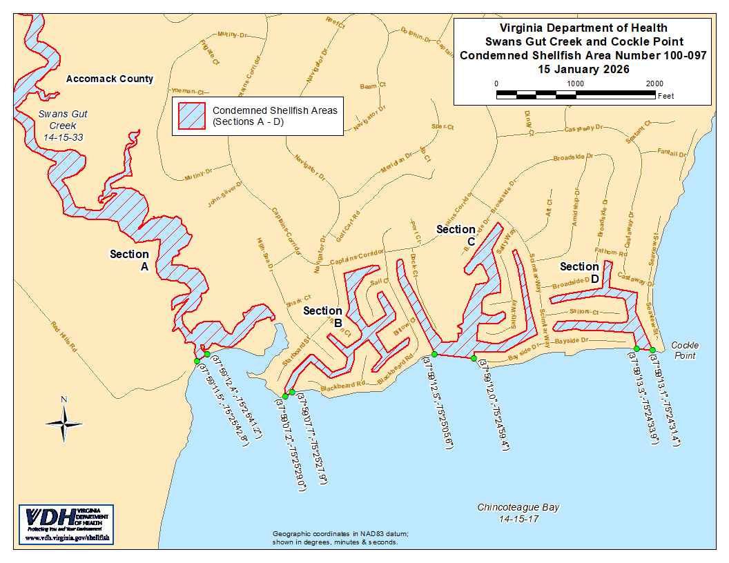
2. የተከለከለ የሼልፊሽ አካባቢ ቁጥር 100-097፣ እንደ ክፍል A እስከ D የሚታየው፣ ከ 15 ጃንዋሪ 2026 ጀምሮ በዚህ ተቋቁሟል። በVirginia ኮድ § 28.2-810 እንደተደነገገው፣ በMarine Resources Commission ከተሰጠ ፈቃድ ውጪ፣ ማንኛውም ሰው፣ ድርጅት ወይም ኮርፖሬሽን ከእነዚህ አካባቢዎች ለየትኛውም ዓላማ ሼልፊሽ መውሰድ ሕገ-ወጥ ነው። የእነዚህ አካባቢዎች ወሰኖች “Swans Gut Creek and Cockle Point, የተከለከለ የሼልፊሽ አካባቢ ቁጥር 100-097፣ 15 ጃንዋሪ 2026” በሚል ርዕስ በተዘጋጀው ካርታ ላይ ይታያሉ፣ ይህም የዚህ ማሳወቂያ አካል ነው።
3. በሁኔታዎች የጸደቀ የሼልፊሽ አካባቢ (የተዘጋ ሁኔታ) ቁጥር 100-097፣ እንደ ክፍል M1 የሚታየው፣ ከ 15 ጃንዋሪ 2026 ጀምሮ ተግባራዊ እንዲሆን ተመስርቷል፣ እና እስኪሰረዝ ድረስ በሥራ ላይ ይቆያል። በVirginia ሕግ § 28.2-810 ላይ እንደተገለጸው፣ በMarine Resources Commission ከተሰጠ ፈቃድ በስተቀር፣ በማንኛውም ሰው፣ ድርጅት ወይም ኮርፖሬሽን በዚህ ወቅት ከዚህ አካባቢ ሼልፊሽ መውሰድ ሕገ-ወጥ ነው። የዚህ አካባቢ ወሰኖች “Swans Gut Creek and Cockle Point, Condemned Shellfish Area Number 100-097, 15 January 2026” በሚል ርዕስ በተዘጋጀው ካርታ ላይ ይታያሉ፣ ይህም የዚህ ማሳወቂያ አካል ነው።
4. የጤና መምሪያው በማንኛውም ጊዜ በማንኛውም ፍላጎት ያለው አካል የሚቀርቡ አቤቱታዎችን ይህንን ትዕዛዝ እንደገና እንዲታይ ወይም እንዲሻሻል በተመለከተ ይቀበላል፣ ይመለከታል እንዲሁም ምላሽ ይሰጣል።
የተወረሰ ቦታ ቁጥር 100-097ወሰኖች
ሀ. የተከለከለው አካባቢ በኬክሮስ/ኬንትሮስ ካርታ መጋጠሚያ (37°59'11.5",-75°25'42.8") እና በመጋጠሚያ (37°59'12.4",-75°25'41.2") መካከል በተሳለ መስመር ላይ የሚገኘውን የSwans Gut Creek ክፍል ያካትታል።
ለ. የተከለከለው አካባቢ በኬክሮስ/ኬንትሮስ ካርታ መጋጠሚያ (37°59'07.2",-75°25'29.0") እና በመጋጠሚያ (37°59'07.7",-75°25'27.9") መካከል በተሳለ መስመር ውስጥ የሚገኙትን ሁሉንም የካፒቴንስ ኮቭ (Captains Cove) ሰፈር ያልተሰየሙ ቦዮች በምዕራብ በኩል ያለውን ክፍል ያካትታል።
ሐ. የተከለከለው አካባቢ የኮክል ፖይንት ወደብን (Cockle Point Harbor) እና ስም ያልተጠቀሰውን የካፒቴንስ ኮቭ (Captains Cove) ሰፈር ቦይ ክፍል ያካትታል፤ ይህም በኬክሮስ/ኬንትሮስ ካርታ መጋጠሚያ (37°59'12.5",-75°25'05.6") እና በመጋጠሚያ (37°59'12.0",-75°24'59.4") መካከል በተሳለ መስመር የውስጠኛው ክፍል ነው።
D. የተከለከለው አካባቢ በኬክሮስ/ኬንትሮስ ካርታ መጋጠሚያ (37°59'13.3",-75°24'33.9") እና በመጋጠሚያ (37°59'13.1",-75°24'31.4") መካከል በተሳለ መስመር ውስጥ የሚገኙትን ሁሉንም የምስራቃዊ ያልተሰየሙ የCaptains Cove ሰፈር ቦዮችን ያካትታል።
M1. በሁኔታዎች የጸደቀው አካባቢ (የተዘጋ ሁኔታ) የኮክል ፖይንት ሃርበርን (Cockle Point Harbor) እና ያልተሰየመው የካፒቴንስ ኮቭ (Captains Cove) ሰፈር ቦይ ክፍልን ያጠቃልላል፤ ይህም በኬክሮስ/ኬንትሮስ ካርታ መጋጠሚያ (37°59'12.5",-75°25'05.6") እና በመጋጠሚያ (37°59'12.0",-75°24'59.4") መካከል በተሳለ መስመር ወደ ላይኛው እና ወደ ውስጥኛው ክፍል፤ እንዲሁም በመጋጠሚያ (37°59'12.9",-75°24'59.3") እና በመጋጠሚያ (37°59'14.2",-75°24'58.9") መካከል በተሳለ ሁለተኛ መስመር ወደ ታችኛው ክፍል፤ እንዲሁም በመጋጠሚያ (37°59'16.4",-75°24'58.5") እና በመጋጠሚያ (37°59'17.7",-75°24'58.3") መካከል በተሳለ ሦስተኛ መስመር ወደ ታችኛው ክፍል፤ እንዲሁም በመጋጠሚያ (37°59'21.2",-75°24'59.1") እና በመጋጠሚያ (37°59'19.7",-75°24'57.8") መካከል በተሳለ አራተኛ መስመር ወደ ታችኛው ክፍል፤ እና እንደ ክፍል C አካል ሆኖ ይታያል።