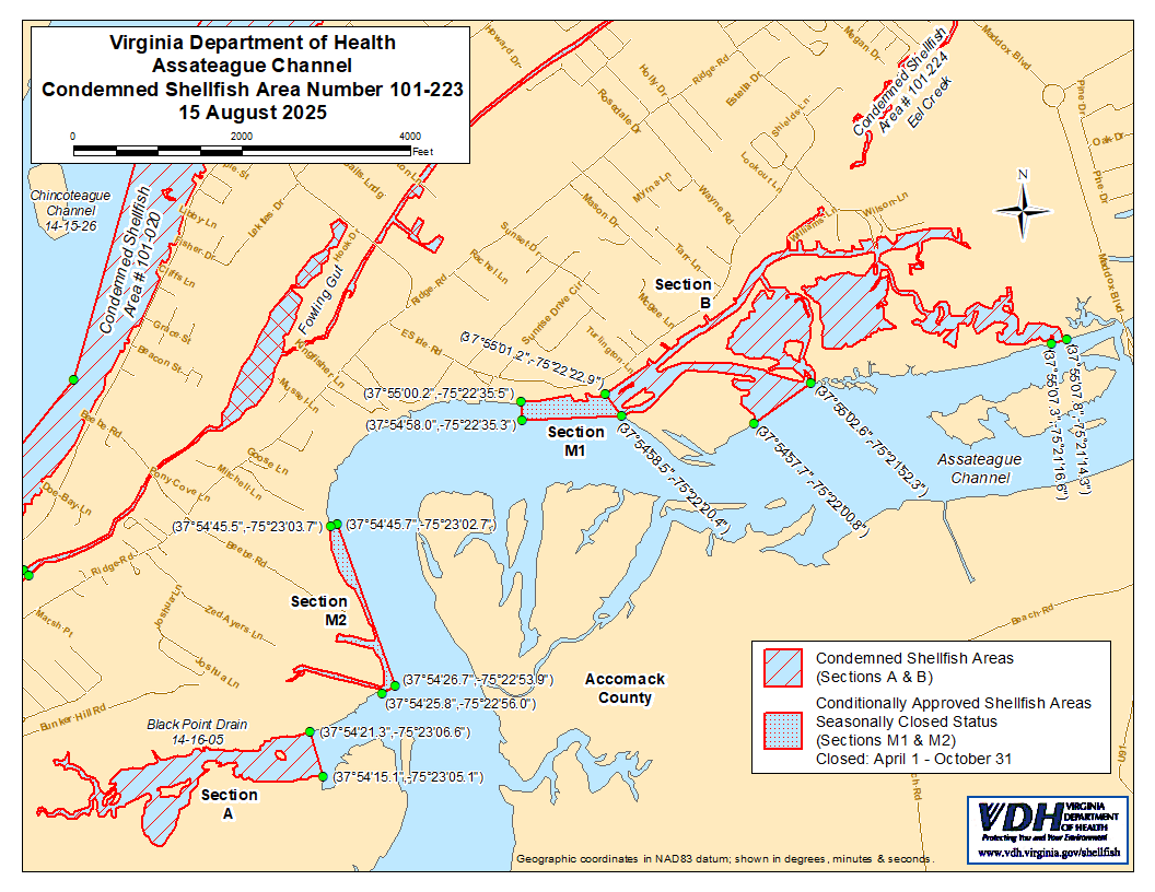
የሼልፊሽ (የባህር ውስጥ ዛጎል ያላቸው እንስሳት) አካባቢ ክልከላ ማስታወቂያ እና መግለጫ
ቁጥር 101-223፣ ASSATEAGUE CHANNEL
ከ 15 ኦገስት 2025ጀምሮ ተግባራዊ የሚሆን
በአርዕስት 28.2 መሠረት፣ ምዕራፍ 8፣ §§ 28.2-803 እስከ 28.2-808፣ § 32.1-20፣ እና § 2.2-4002፣ B.16 of the Code of Virginia:
1. “የሼልፊሽ አካባቢ እገዳ ማስታወቂያ እና መግለጫ ቁጥር 102-223፣ Assateague Channel”፣ ከኤፕሪል 14 2008 ጀምሮ ተግባራዊ የነበረው፣ ከኦገስት 15 2025 ጀምሮ ተሰርዟል።
2. ክፍል A እና B ተብለው የተመለከቱት፣ የተከለከለ የሼልፊሽ አካባቢ ቁጥር 101-223፣ ከ 15 ኦገስት 2025 ጀምሮ ተግባራዊ እንዲሆን በዚህ ተቋቁሟል። በVirginia ኮድ § 28.2-810 እንደተደነገገው፣ በMarine Resources Commission ከተሰጠ ፈቃድ ውጪ፣ ማንኛውም ሰው፣ ድርጅት ወይም ኮርፖሬሽን ከእነዚህ አካባቢዎች ለየትኛውም ዓላማ ሼልፊሽ መውሰድ ሕገ-ወጥ ነው። የእነዚህ አካባቢዎች ወሰኖች “Assateague Channel, Condemned Shellfish Number 101-223, 15 August 2025” በሚል ርዕስ በተዘጋጀው እና የዚህ ማስታወቂያ አካል በሆነው ካርታ ላይ ይታያሉ።
3. በሁኔታዎች የጸደቀ (በወቅታዊ ሁኔታ የተዘጋ) የሼልፊሽ አካባቢ ቁጥር 101-223፣ እንደ ክፍል M1 እና M2 የሚታየው፣ ከኦገስት 15 ቀን 2025 ጀምሮ የተቋቋመ ሲሆን፣ ከዚያ በኋላ በየዓመቱ ከኤፕሪል የመጀመሪያ ቀን እስከ ኦክቶበር የመጨረሻ ቀን ድረስ እስኪሰረዝ ድረስ በሥራ ላይ ይቆያል። በተዘጋበት ሁኔታ ውስጥ በሚቆይበት ጊዜ፣ በMarine Resources Commission ከተሰጠ ልዩ ፈቃድ በስተቀር፣ በVirginia ህግ ክፍል § 28.2-810 እንደተደነገገው፣ ማንኛውም ሰው፣ ድርጅት ወይም ኮርፖሬሽን ከእነዚህ አካባቢዎች የባህር ውስጥ ሼልፊሽ (shellfish) መውሰድ ህገወጥ ነው። የእነዚህ አካባቢዎች ወሰኖች “Assateague Channel, Condemned Shellfish Number 101-223, 15 August 2025” በሚል ርዕስ በተዘጋጀው ካርታ ላይ ይታያሉ፤ ይህም የዚህ ማስታወቂያ አካል ነው።
4. በሁኔታዎች የጸደቀ (ክፍት ሁኔታ) የሼልፊሽ አካባቢ ቁጥር 101-223፣ እንደ ክፍል M3 የሚታየው፣ ከኦገስት 15 ፣ 2025 ጀምሮ ተግባራዊ እንዲሆን ተወስኗል፣ እና ከዚያ በኋላ እስኪሰረዝ ድረስ በየዓመቱ በሥራ ላይ ይቆያል። በዚህ አካባቢ የተዘጋ ሁኔታ በሚኖርበት ጊዜ ማንኛውም ሰው፣ ድርጅት ወይም ኮርፖሬሽን ለየትኛውም ዓላማ ሼልፊሽ (shellfish) መውሰድ ሕገ-ወጥ ነው፤ ሆኖም በVirginia ሕግ አንቀጽ § 28.2-810 መሠረት በMarine Resources Commission ከተሰጠ ፈቃድ በስተቀር። የዚህ አካባቢ ወሰኖች “Assateague Channel፣ የተከለከለ ሼልፊሽ ቁጥር 101-223፣ ኦገስት 15 ፣ 2025” በሚል ርዕስ በተዘጋጀው ካርታ ላይ ይታያሉ፤ ይህም የዚህ ማስታወቂያ አካል ነው።
5. የጤና መምሪያው በማንኛውም ጊዜ በማንኛውም ፍላጎት ያለው አካል የሚቀርቡ አቤቱታዎችን ይህንን ትዕዛዝ እንደገና እንዲታይ ወይም እንዲሻሻል በተመለከተ ይቀበላል፣ ይመለከታል እንዲሁም ምላሽ ይሰጣል።
የተወረሰ ቦታ ቁጥር 101-223ወሰኖች
ሀ. የተከለከለው አካባቢ ሁሉንም የብላክ ፖይንት ድሬይን (Black Point Drain) እና ከኬክሮስ / ኬንትሮስ ካርታ መጋጠሚያ (37°54'15.1",-75°23'05.1") እስከ ካርታ መጋጠሚያ (37°54'21.3",-75°23'06.6") ከተሳለ መስመር በላይ ያሉ ገባር ወንዞቹን ያካትታል።
ለ. የተከለከለው አካባቢ የሺፕስሄድ ክሪክን (Sheepshead Creek) በሙሉ እና ገባር ወንዞቹን፣ በኬክሮስ / ኬንትሮስ ካርታ መጋጠሚያ (37°55'01.0" ,-75°22'23.1") እና በካርታ መጋጠሚያ (37°54'58.6" ,-75°22'20.2") መካከል በተሳለ መስመር ወደ ውስጥ እና ወደ ላይኛው ክፍል፣ እንዲሁም በካርታ መጋጠሚያ (37°54'57.7" ,-75°22'00.8") እና በካርታ መጋጠሚያ (37°55'02.6" ,-75°21'52.3") መካከል በተሳለ መስመር ወደ ውስጥ፣ እና እንዲሁም በካርታ መጋጠሚያ (37°55'07.3" ,-75°21'16.6") እና በካርታ መጋጠሚያ (37°55'07.8" መካከል በተሳለ መስመር ወደ ውስጥ ያለውን አካባቢ ያካትታል። -75°21'14.3").
M1. በሁኔታዎች የጸደቀው አካባቢ (በወቅታዊ ሁኔታ የተዘጋ)፣ በአሳቴግ ቻናል (Assateague Channel) ውስጥ፣ በኬክሮስ / ኬንትሮስ ካርታ መጋጠሚያ (37°55'00.2",-75°22'35.5") እና በካርታ መጋጠሚያ (37°54'58.0",-75°22'35.3") መካከል በተሳለ መስመር ውስጥ የሚገኘውን ክፍል ያካትታል፣ የካርታ መጋጠሚያ (37°54'58.5",-75°22'20.4")፣ እና የካርታ መጋጠሚያ (37°55'01.2",-75°22'22.9")።
M2. በሁኔታዎች የጸደቀው አካባቢ (በወቅታዊ ሁኔታ የተዘጋ)፣ በአሳቴግ ቻናል (Assateague Channel) ውስጥ፣ በኬክሮስ / ኬንትሮስ ካርታ መጋጠሚያ (37°54'25.8",-75°22'56.0") እና በካርታ መጋጠሚያ (37°54'26.7",-75°22'53.9") መካከል በተሳለ መስመር ውስጥ የሚገኘውን ክፍል ያካትታል፣ የካርታ መጋጠሚያ (37°54'45.7",-75°23'02.7")፣ እና የካርታ መጋጠሚያ (37°54'45.5",-75°23'03.7")።
M3. በሁኔታዎች የጸደቀው አካባቢ (ክፍት ሁኔታ) በኬክሮስ / ኬንትሮስ ካርታ መጋጠሚያ (37°54'52.1",-75°23'02.7") እና በካርታ መጋጠሚያ (37°54'51.3",-75°23'01.3") መካከል በተሳለ መስመር ውስጥ የሚገኘውን የAssateague Channel ክፍል ያካትታል። የካርታ መጋጠሚያ (37°54'55.6",-75°22'56.9")፣ እና የካርታ መጋጠሚያ (37°54'56.4",-75°22'58.1")፤ ነገር ግን በሪፖርቱ ውስጥ ብቻ ነው የሚታየው።